Picturing Paris: Sites and Sights of the City

byCrecia Cipriano

Introduction and Rationale

The French language and culture often seem quite removed from the lives of my students. Whereas they see and hear evidence of the "point" of learning Spanish literally daily, it is often more difficult to convince them of the practical benefits of learning French. Although there are indeed plenty, perhaps the key is to finally drop the pretense that the competition is comparable in terms of present day, everyday relevance, and instead set our sights on the future, full as it is of possibility. Paris is the City of Lights! It's a city that begs to be dreamt of, that resonates with mystique and allure. So let's use that! Let's compel the adventurous nature of our future travelers and explorers through image-rich activities that will lead students to learn about the city based on what draws them in, familiarizing themselves with the landmarks that interest them most, and developing a conception of the city that has individualized meaning and significance.

In the second marking period of the eighth-grade World Languages French curriculum in New Haven, students are invited to explore their own neighborhoods and communities, learning how to describe where they live and placing their homes in relation to other landmarks, streets, and locations (like supermarkets, libraries, schools, etc.). Students generally have success with this part of the unit because the learning is applied within the context of their own neighborhoods, with which they are both familiar and comfortable. Next, however, we move from that relatable space to one less recognizable and more intimidating; we explore well-known monuments, buildings, and sites within Paris. Not only are students less certain in this space, often feeling overwhelmed by all they feel they don't know about this beautiful city, but frankly so am I. The only time I spent in France was sixteen years ago now, and during that time I spent only a few hours here and there in Paris. Even though I lived just a couple hours away, the magnitude of all that the city held was overwhelming to me; I didn't even know where to start! So I picked a few places and absorbed their surroundings as I went. The results of such uninformed wandering were sometimes comical, but it always led to an enriched experience of and connection to those places.

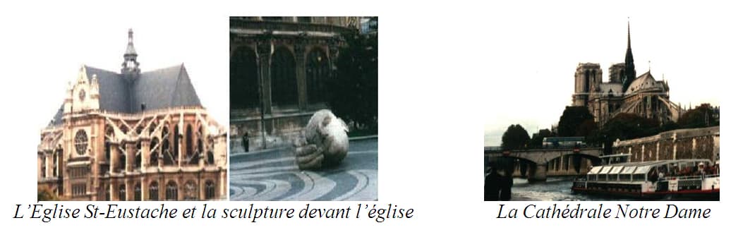
During one short visit, my friends and I marveled at the beauty of what we thought was Notre Dame Cathedral. We later marveled again, this time at our error; when we tried to find out more about the beautiful stone sculpture we had seen in front of it (of a very large head that looks to be resting in a very large hand), we discovered that we had actually been outside of L'Église St. Eustache and not La CathÉdrale Notre Dame! In fairness to us, they were both built in the gothic style, but logistically they are located several neighborhoods, or arrondissements, away from each other (Notre Dame in the 4 th and St. Eustache in the 1 st). What we lacked in knowledge we made up for in pure enjoyment of the place. We spent quite a while in the courtyard outside the church, drinking it all in, appreciating the whole atmosphere. By letting ourselves be drawn in by the beauty and magnetism we felt there rather than just making a forced beeline to sites that must be seen, we were treated to a special experience of a place that we may have likely missed on any literal or figurative "highlights of Paris" tour.

Below: The pair of images to the left is L'Église St-Eustache, with a close up of that intriguing statue, L'Écoute. To the right is La CathÉdrale Notre Dame. 1

image 13.01.07.01

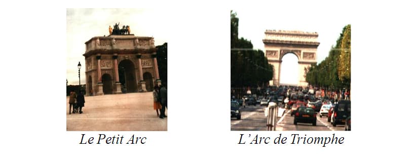
My friends and I also pointed at and posed in front of what we had thought was the Arc de Triomphe, perhaps a little surprised at its size, expecting something bigger and more grand. Something more like what we saw when we actually got over to La Place Charles de Gaulle at the base of Les Champs-ElysÉes (at the border of the 8 th, 16 th, and 17 th arrondissements), where the actual Napoleonic Arc de Triomphe is, as opposed to this smaller Petit Arc or Arc de Triomphe du Carrousel between Le Louvre and Le Jardin des Tuilleries (again, 1 st arrondissement, same day as the St-Eustache debacle)! In both cases, we were inspired to do some research into the places we had seen once we got back home, and that research was so much more meaningful to us than reading up ahead of time would have been, inspired as it was by our authentic curiosity and experiential "discoveries!"

Below: To the left is the Petit Arc and to the right is the "real" Arc de Triomphe.

image 13.01.07.02

Objectives

In this unit, I propose that we take a page from those bumbling ways of my college days and have students choose locations to explore based on interest and curiosity rather than on top-ten lists of best-known, must-see spots. As they embark on a kind of picture walk through Paris, students will learn to describe what they see as well as the relationship between points (if they are near to or far from each other, for example). By looking at those places, those parts, in relationship to each other, they will begin to construct a sense of the city as a larger whole. By weaving back and forth between a larger-scale city map and pop-out, up-close "visits" to landmarks within neighborhoods through photographs and artwork, students will, I hope, develop a stronger sense of familiarity and confidence in what they come to know about Paris.

Images will be used in this unit to prompt language practice as students describe where they are "going to" or "coming from" and what they see there. They will distill their "experience" of each place down to its most essential elements, combining an image of the location with a key word or concept to create something similar to a comic-book panel. The words and concepts will meld with the images, creating visual-linguistic memory markers of the journey that will then be integrated into maps of the city, representing the physicality of place while also conveying aspects of place that inspire attachment. In this way I hope that our students may start to develop fluency not only in the French language but also in the geography and iconography of this most celebrated of cities.

When students are asked to present to the class, they often rely on reading what they've written on their supporting materials, a process that is boring for the audience and gives students the experience of simply reading rather than communicating. This is so very important for the true development of linguistic expression, and it is difficult for students to understand how to make the jump because in their English language classes they tend to struggle similarly. So in this unit there will be elements of both presentation and conversation, providing a balance between preparation in advance and spontaneous interaction. By having students distill each landmark down to key words or phrases, they will automatically begin examining and gathering what they consider to be important language and information relevant to the landmark; in this way the key words or phrases, if well-chosen, will then jog the memory of those other necessary language functions during presentation and conversation.

In our seventh-grade curriculum, more stress is placed on developing writing skills than it was in the fifth and sixth grades, both of which are more focused on oral expression and vocabulary-building. In eighth grade, everything gets more complex! Students have now developed such a wide array of language skills that situations call for picking and choosing appropriate ones; now there are even more ways than before to get at communication goals, so not only do students have to have a strong enough handle on all previous and current learning to know what to choose, but they also then have to keep language and grammar rules and exceptions in mind. So much choice and freedom can be overwhelming for students. This is that critical time when they will rise to the occasion and develop a thrill and taste for exploring language, or else they will tune out due to the ever-increasing challenges. It is obviously my goal to facilitate the former rather than the latter. I hope that this unit provides a solid structure within which students may and must make these more complex language choices.

Language Learning and Visual Images: Imagetexts as Memory Markers

Throughout the course of this seminar in Picture Writing, we have discussed the complex interplay between words and images, dissecting varied levels of effectiveness in terms of expression of information. A clear, uncluttered, and meaningfully selected or created image can say more on its own than it would if language were to be lazily or carelessly added, just as an effective and purposeful linguistic message might be obscured by vague or overpowering images. But when both language and image are consciously and carefully selected and combined, words and image can work in synergy to convey meaning most clearly, on perhaps a more holistically felt level.

As language teachers, we are always looking to find something familiar in a word or phrase — be it a legitimate word root or a silly random connection to the sound or look of a word that will help a student remember it. We also rely on images to express meaning in order to reduce the amount of English spoken in class. Exploring these connections between image and text leads to even more conscious and purposeful choices of images, both with and without accompanying or supportive text, in all classroom transactions.

In the essay "Beyond Comparison: Picture, Text, and Method," W.J.T. Mitchell uses the term imagetext to denote a synthesized combination of image and text. 2 In this unit I ask students to combine words (in the form of French language vocabulary) and images (of landmarks in Paris) into a cohesive entity that embodies both information and vocabulary learning related to the place, as well as any emotional connection that is evoked. These created imagetexts may contain one word, strings of words, or a sentence, as dictated not only by language fluency but also by whatever factors of emotion are at play.

As students explore Paris over the course of this unit, they will be asked to create imagetexts of each spot in sketch or draft form, constructing a skeleton of an image with a shade of the affective or atmospheric tone the place holds for the student, and incorporating self-chosen key words or phrases that best evoke both the factual as well as the emotional truth of the place for that student. They will record these interactions with places in a sketchbook that will function as their scrapbook of Paris. From this larger personal collection of reflections and observations, students will choose their favorites to use in the creation of their personalized site map of Paris. See "Activity II: Imagetext Scrapbook" in the Classroom Activities section of this unit.

In his book Understanding Comics, Scott McCloud explains different ways of combining image and text in comic-strip panels, depending on whether the image or the text is more prominent or whether the two are equally important to the meaning of the panel. 3 There are also distinctions made concerning how the words function in the panel. Here I will bend those concepts to fit the language-learning needs of imagetext creation in my classroom. At the outset of the unit, students should be given a brief explanation of the categories explained below, so that they may approach their scrapbook drafts with this in mind if they'd like. But since the scrapbook portion of this unit is really meant to be experiential, personal, and reflective, I don't want students bogged down by too many requirements at that stage. So although they should be aware of the ultimate expectations, they should not get overly concerned with them until they are working on their favorites for the final drafts.

All imagetexts in this unit will be created with an equal partnership between words and image; it is what the words are saying or how they are functioning in relation to the image that will change. Words will either: 1) reflect the image, 2) reflect knowledge about the image, or 3) reflect feelings about or evoked by the image. Put another way, students will create imagetexts that describe, tell, and connect.

    IMAGETEXT OPTIONS:

    Words Reflect Image
      (words and image say same thing)
        DESCRIBING

    Words Reflect Knowledge about Image
      (words and image say different but complementary things)
        TELLING

    Words Reflect Feelings / Words Do Not Reflect Image
      (words and image say different things)
        CONNECTING
  

After they have researched and explored sites within Paris, students will practice describing, telling about, and connecting to (or expressing feelings about) the landmarks they have "visited" in Paris. Depending on language strengths and weaknesses and what you think each student should try to accomplish, you will select a guideline for the finished product. For example:

Create ten final imagetexts. Two must describe, two must tell, two must connect, two must describe and tell, and two must connect and describe or tell.

That guideline would give students a degree of freedom while still requiring them to stretch themselves in different and increasingly complex ways. To that end, you may also wish to issue parameters concerning minimum number of sentences and multi-word panels and maximum number of single word panels.

Another option in imagetext creation is a variation on a montage, in which words are used to create the image or a portion of the image. For example, the Eiffel Tower could be "drawn" out of words that tell about it, so that the lines of the drawing are made of the selected telling keywords, or the gargoyle detail at the top of Notre Dame could be created out of emotional connection words and the rest of the image could be straight image or image combined with background describing words. Much like the panels explained above, these montages can be categorized as those that describe, those that tell, and those that connect.

Alternatively, students may choose to model the image portion of their imagetexts on the related street-view illustrations found in Robinson's Paris Line by Line. In these illustrations, several landmarks are sketched in a single panel as they appear on the length of a street, for example. So for our purposes, each landmark and corresponding text would constitute one imagetext, even though it is in the larger frame of several other landmarks on a page. Here, words could be incorporated into the buildings themselves or they could occupy the white space in some aesthetically impressive and mood-enhancing way.

Introducing Landmarks: Image and Icon

The foundation of this unit is student exploration of landmarks within Paris. In order to allow students the opportunity to respond intuitively, based purely on visual aesthetics and personal interests, I suggest displaying photographic print-outs of landmarks on folding presentation boards according to location category, as indicated by symbols or icons. I have gathered a collection of clip art images for denoting locations by type (museum, monument, bridge, etc.). See Appendices B + C (Arrondissments and Location Icons). Icon, pictogram, symbol, isotype — these are all more or less synonyms denoting an image that conveys or represents an idea, meaning, or category, in a clear and easily recognized way so that it may be used for communication purposes. Put another way, these images function as if they were language; in this unit the clip art selected is used to identify sites by category or type.

Each display board will represent one category or type of location, and laminated photographic images will be attached to the boards with magnets or restickable adhesive. The photo cards will be labeled with the icon for the location category and the appropriate arrondissement number graphic. Students will choose sites to explore based on the photographic image of the place and the icon, without any indication of place names, or indeed any language about the places. In this way, students will make their choices based on what they see in the pictures, perhaps inspired by the details displayed in the photographic representation, perhaps compelled to explore a particular type of place, as denoted by the basic categorical information conveyed by the icon.

About images: Before embarking on this unit, there is a lot of preparation to be done in terms of gathering, printing, labeling, and laminating the images for use. But they will be well used throughout this unit, and may be reused in other units. By laminating them, you are creating supplies that will last a long time, and I highly recommend that you set aside enough time well before the unit in order to do this properly. However, if that is not possible, I would recommend printing the images on cardstock so that they will at least hold up over the course of the unit. See "Images" in the Website Resources section for a list of recommended websites for good landmark images.

The way students will explore these sites will depend on the type of access to technology you have. In the "General Class Use" part of the Website Resources section of this unit, I have listed some websites that I found both informative and expansive in terms of landmarks they present. I have indicated whether they are French, English, or have options for both. I recommend the French sites for class exploration and the English for student reference and exploration at home. Of course, expectations must be clearly set for students so that they don't just jump to the English at every turn. I think that allowing them the option of exploring the English information at home will help them to stay in French in class since they know they will have an opportunity as part of their assigned homework to do further research. Also, following through on questions with work at home, sometimes done in English, will help build and maintain interest in the locations so that students learn far more than they would if their knowledge base were limited to what they can understand or decode from the French. They will then be more motivated to learn how to say what they want to say about the place in French and to share that with classmates and others.

If you have full class access to a computer lab or set of tablets/laptops, then everyone can work and explore at once. If you've got only a few classroom computers, then you may choose to create a "Centers" set-up, in which computer exploration would be one out of several centers. Others could be: exploration of (probably English language) classroom resource reference books and travel guides; exploration of French language printouts from resource sites; mapping activities – locating given sites on a map of Paris, following printed directions on a map; conversation prompts; classifying your sites by arrondissement; gathering all the landmarks from the presentation boards that belong in a particular arrondissement (and mapping them or not), writing and practicing a skit, creating a song/dance. With all centers work, be sure to have requirements and expectations structured so that it is an efficient and productive use of time. I find that things run most smoothly and effectively when I have an overarching organizational check-off sheet that asks students to include the date completed and list the initials of any partners for each center. In this way, students may work over the course of several class sessions without losing a sense of accountability, working at individually developmentally appropriate paces. When we are done with the centers (even if everyone hasn't completed everything), I ask students to put the completed check-off sheet on top and then put all work in order of the sheet and staple it all together. Then I have a record of their progress from which I can learn and make necessary adjustments to individual or class instruction.

Over the course of the unit, some days students will be exploring on their own, other days will be devoted to teacher-led explorations of places, and still others will provide an opportunity for students to work in pairs and small groups to map locations, share learning, and participate in communication activities. When discussing a site, we will place the building or monument in the context of its neighborhood, as well as explore notable relevant information and some details about what it looks like. This will allow us to reinforce prior language learning as well as give students more opportunities for making connections.

  • SUGGESTED LOCATIONS CATEGORIES*:
  • Arrondissement (District/Quarter) / Arrondissement
  • Bridge / Pont
  • Cemetery / Cimitière
  • Entertainment / Divertissement
  • Fountain / Fontaine
  • Garden / Jardin
  • Government building / Mairie
  • Monument / Monument
  • Museum / MusÉe
  • Park / Parc
  • Plaza/Promenade / Place/Promenade
  • Church/Place of Worship / Église/Lieu de Culte
  • Restaurant / Restaurant
  • Shop(s) / Magasin(s)
  • Train Station / Gare
  • Waterway / Eau/Voie navigable

*You may want to add more categories or change these. Other locations you may particularly wish to include are hotels or schools, for example. There are two blank spots on the Location Icons graphic in Appendix C so that you may easily add others as you see fit.

Again, students may select locations based on the sheer aesthetics of a place or they may be drawn to certain types of places based on a pre-existing interest. As they explore, they may decide that they are interested in learning more about a particular neighborhood or category of location site. In offering such flexibility for interest-driven research, it is vital that information be well organized graphically, both in individual student records and note taking as well as during whole class and partner activities. Mapping on a small scale, or mini-mapping, as I like to call it, will help students to organize and synthesize their understanding of places as they build up a knowledge base.

Over the course of this unit, you will likely want students to mini-map by both neighborhood (which will include a variety of site types) and site type (which will span the whole or at least a good part of the city). For example, in mapping the neighborhood of the first arrondissement, a student could learn about and identify the locations described in the following paragraph (just as another student could come up with an entirely different focus for a 1 st arrondissement exploration). But a mapping of museums within Paris, for instance, would show and discuss maps throughout the whole of Paris, not just those within the confines of one neighborhood. (I have italicized the French place names and bolded the English category terms in the following paragraph to draw attention to the diversity of location types represented.)

The Pont Neuf — actually the oldest bridge in Paris despite its name ("the New Bridge," which was accurate in the early 1600s when it was built) — crosses over the river Seine at the southeast end of the 1 st arrondissement. To the west of it is the Louvre museum, and to the west of that, at the southwest end of the 1 st arrondissement, is the Tuilleries garden. Between the Louvre and the Tuilleries is that smaller Arc de Triomphe du Carrousel that was discussed in the unit's introduction. Just north of the Pont Neuf is Les Halles for shopping and just north of that is our beloved and also previously discussed Saint-Eustache church. Across the arrondissement from Les Halles (to the west) is the Place Vendôme, which is a plaza and also has a monument.

These mini-mapping activities will pave the way for the culminating mapping process that will be used for presentation and discussion of learning, explained in the following section.

Maps + Prezi

The free-form exploration completed via scrapbooking and mini-mapping will lead into the polished final process of map-making and presenting. From the scrapbook imagetext sketches and notes, students will select a given number of their favorites to create in final draft form. These ultimate imagetexts will be used in the creation of personalized site maps of Paris.

Prezi is a virtual whiteboard that can be used to create interactive presentations that combine image and language in a visually impressive and engaging manner. I will use Prezi to set the stage for our explorations every day, starting from a map of Paris proper and then zooming in to specific locations and then back out, linking to resources that will illuminate the city for students — photographs, works of art, videos, and audio clips. Sometimes I will highlight places several students have explored, to give them an opportunity to show what they know or else to correct misconceptions revealed in daily homework check or observed in class work the previous day. Other times I will highlight places that have not been very popular, both to drum up interest and to provide at least a surface knowledge of the place.

Students may wish to use Prezi in the creation of their personalized maps. See "Activity III: Personalized Site Maps, Presentations" in the Classroom Activities section of this unit.

Language Matters: Discussing Landmarks

Before they start work on this unit, students will have just completed a more general unit on locations within a city, starting with a general sense of these places and then applying them to locally relevant cities. 4 They will have used prepositional phrases to make relational comparisons between landmarks within their own cities, such as supermarkets, parks, museums, and schools, and they will have given and followed directions between points on a map. In this unit, which is really the next component of that unit, students will identify landmarks they learn about within Paris and describe them (a skill practiced in the unit that occurred just before the local locations one, as they described their homes and rooms within those homes). Introducing the sites they explore in Paris will be the basis of communication activities among students. At first, the tasks will focus on one location at a time; later, students can introduce several locations at once, explaining to each other how the locations are related on a map and perhaps asking fellow students to follow directions on a map in order to get from one location to another. You may want to introduce Metro maps and relevant vocabulary in order to facilitate "travel" between distant locations.

Unit vocabulary will largely depend on what you have taught previously. The following is a basic selection of unit-specific vocabulary and grammar concepts:

Talking About Landmarks

  • Voilà ... (Name of Location). Here is....
  • Il/elle est dans le X ième arrondissement. It is in the X st/rd/th arrondissement/quarter/district.
  • Il/elle est (adjective) et (adjective). It is (adjective) and (adjective).
  • Il/elle est près de (a location) et loin de (another location). It is near to (a location) and far from (another location).
  • C'est un/une... (building type) ... (adjective). It is a (adjective) (building type).
  • Adjective agreement and placement
  • Use of Il/Elle est vs. C'est.

Coming and Going, Near Past and Near Future

  • Aller à + location— to go to a location
  • Venir de + location — to come from a location
  • Aller + verb infinitive— to be going to do something (Near future/ Futur proche)
  • Venir de + verb infinitive — to have just done something (Near past / PassÉ proche)
  • À + Definite Article / De + Definite Article

Present-Tense Verbs — What I am Doing There

  • Regular –ER verbs – first person singular
  • Exception — ER verbs – first person singular
  • (Perhaps third person plural forms of verbs)

Classroom Activities

Activity I: Unit Opener/Closer

I will open the unit with a roughly five-minute video I found on YouTube called Paris avec Edith Piaf (Paris with Edith Piaf). This video is one of several from the poster Le Monde en VidÉo (The World in Video), which includes videos that last from around five to ten minutes of landscape, architecture, and scenery around the world, from such places as Turkey, Egypt, and Italy, in addition to France. These videos are not narrated; the ones that aren't accompanied by music do have audio, so you can hear the natural sounds of the crowd. The poster has one on La CathÉdrale Notre Dame, one on Le MusÉe de l'ArmÉe, and one on Le Tombeau at L'Hôtel Nationale des Invalides.

While students are watching the video, I will ask them to list anything they recognize, any places or landmarks or notable features they see. We will do this again at the end of the unit to see how much more they recognize.

Activity II: Imagetext Scrapbook

Give students (or ask them to bring in) a sketchbook or composition book. This will serve as the journal/scrapbook of their "travels" to Paris. For a homework assignment, have students decorate the cover as well as the front page. The title can be something like "Mon Paris" or "Mon voyage à Paris." First, you may want to have them brainstorm a list of ten words they think of when they think of Paris; if they don't know a word in French, they can look it up and submit it to you (to see if they indeed selected the most appropriate word from the dictionary.)

Have students write their name, the date, and the name of the landmark as a heading on the right-hand page and then create their imagetext on that page, using only French vocabulary and sketching. Each landmark should be sketched on the right page of the book, so that when opened up there will be a paired blank left-hand page. On the left-hand side of the sketchbook, students will write questions they still have, information they learned, or vocabulary they want to research. Whatever they can or are compelled to do in French on this page is strongly encouraged, but there may be information that they can't put meaningfully in French, and the left-hand page is a safe space for English language use.

Just as a traveler often jots things down during the day and also reflects at night, so the students will also review the day's work at night, researching answers to questions, searching for needed vocabulary, exploring the topic more thoroughly. If students run out of space on the two-page spread dedicated to that location, they may paperclip or tape additions into the spread. Alternatively, students may make pocket folders or designate envelopes for extra material and then label that material with the name of the corresponding landmark and the date entered.

Students will not be able to hand in their scrapbooks every day because they will be used for homework reflection. But the scrapbooks hold valuable information for the teacher that can be used to drive instruction and guide our focus. So I will either take pictures or ask students to take pictures of their work each day so I can review it.

Additionally, scrapbook entries can be used in conversation activities.

Activity III: Personalized Site Maps, Presentations

Using the guidelines explained in Language Learning and Visual Images: Imagetexts as Memory Markers, students will create their own site maps of Paris, highlighting the locations of their choosing. The sky is really the limit here, in terms of ways this might be done. Students may draw, paint, collage using found paper, collage using images from online or photos, or use Prezi to create a virtual pop-up map. If not working in Prezi, students may draw or print out a map of Paris, affix it to posterboard and draw lines from locations out to imagetexts, forming a type of close-up of the area. Or they could draw a map template on a posterboard (or plastic tablecloth) laid flat and create three-dimensional pop-up locations – see Paper City Paris – Made by Joel in the "Images for Class" Resource section. I've also included in that section a link to an outline map of Paris with labeled departments for use here and elsewhere in the unit.

When students are presenting their maps, ask the class to take notes so that they can then ask them questions. Or, presenters can also be responsible for creating a guided note-taking worksheet for their presentation.

Maps should be graded separately from presentations, and both should be scored with a rubric.

Resources

Books

Image and Text

McQuade, Donald and Christine McQuade. Seeing and Writing 4. Boston: Bedford/St. Martin's Press, 2010.

McCloud, Scott. Understanding Comics. New York: Harper Collins, 1994.

Mitchell, W. J. T. Picture Theory: Essays on Verbal and Visual Representation. Chicago: University of Chicago Press, 1994.

Paris: Background Knowledge, Students and Teacher

Bailey, Rosemary and Katherine Spenley. Paris (Eyewitness Travel Guides). New York: DK Publishing, 1993, 2011. I am a big fan of DK books. They are interesting and informative without being overwhelming, and they are aesthetically inviting as well.

Cole, Robert. A Traveller's History of Paris (Traveller's History Series). Northampton: Interlink Pub Group, 2008. This book is filled with useful historical information, especially for teachers.

Corba, Anna. Doodling in French: How to Draw with Joie de Vivre (Bilingual Edition). San Francisco: Chronicle Books, 2012. This is a great, fun resource for students who want to learn how to draw whimsical details in their imagetexts.

Edwards, Natasha and Roman Klonek. City Walks with Kids: Paris Adventures on Foot. San Francisco: Chronicle Books, 2008. This is a collection of cards that tells about locations in Paris and can provide another format for exploration.

Henry de Tessan, Christina. Forever Paris: 25 Walks in the Footsteps of Chanel, Hemingway, Picasso, and More. San Francisco: Chronicle Books, 2012. Great resource for exploring based on particular interests and for tying in past learning on famous French speakers.

Jones, Colin. Paris: The Biography of a City. New York: Penguin Press, 2004. This gives a comprehensive account of the history of Paris, especially useful for teachers.

Levesque, Kim Horton. The Little Bookroom's Guide to Paris with Child. New York: The Little Bookroom, 2013. Not only does this resource have a lot of clear and practical information, but it also has plenty of photographs as opposed to illustrations.

McCulloch, Janelle. Paris: An Inspiring Tour of the City's Creative Heart. San Francisco: Chronicle Books, 2012. This visually rich and informative book is a great source of background information for teachers as well as students.

Neskow, Vesna. The Little Black Book of Paris, 2013 Edition. New York: Peter Pauper Press, 2012. Thorough guidebook organized by neighborhoods. Strong resource!

Robb, Graham. Parisians: An Adventure History of Paris. New York: W. W. Norton and Company, 2011. A look at the history of Paris and its places as told through the stories of people. Great resource for teachers especially.

Robinson. Paris Line by Line. New York: Universe Press, 2013. Amazing book of illustrations reprinted from the 60s.

Sasek, Miroslav. This is Paris. New York: Universe Press, 2004. Children's book with beautiful illustrations; this can be used as a model for formatting imagetexts or as introductory foundation-setting material for struggling students.

Websites

General Class Use

360 Cities. https://www.360cities.net. This is a collection of panoramic photos from around the world that are geo-referenced; in other words, they are located within space, correlated to points on a map, and can thus be navigated in an interactive fashion and viewed within their neighborhoods. Navigation is a bit cumbersome at first but is well worth it for the virtual experience of "being there." There is an introduction to Paris (in English) here: http://www.360cities.net/area/paris-france. From there you can select sites within Paris.

A View on Cities. www.aviewoncities.com/paris. This site has lots of information on landmarks (in English) with good pictures.

Le Monde en Video (YouTube). "Paris Avec Edith Piaf." http://www.youtube.com/watch?v=TSIw6ktrbgY&list=PL9uNqONsJ8Q8DXBEf-RaJ9vPNuZvMzOho. Video used and explained in "Activity I – Unit Opener/Closer" of the Classroom Activities section of the unit.

Le Nouveau Paris - Île de France. http://www.nouveau-paris-ile-de-france.fr. This site is in French with an option for English.

Paris Info. http://www.parisinfo.com/visiter-a-paris. This is from the Office of Tourism in Paris (in French, with an option for English). The whole site is useful for teachers, but for student research I recommend this link. It includes ways to search for sites in Paris and tells about them in clear and simple French. It also offers lots of photographic images.

Paris-Tourisme. http://www.paris-tourisme.com/indexf.html. This site (in French, with an English option) lists landmarks by category.

Trip Advisor. http://www.tripadvisor.fr/Tourism-g187147-Paris_Ile_de_France-Vacations.html. Travel planning website (in French, with an English option).

Images

In addition to the websites above, here are a few more*:

ARTstor. http://www.artstor.org/index.shtml. This is a nonprofit licensed digital image library holding more than 1.5 million images. I have access to it through the Yale library system, and perhaps you can get access through your school or a local museum, university, or library. By searching "Paris" and then clicking on "Architecture and City Planning" you can access 1,000 images. The images are able to be zoomed in on, for focus on details.

Google – France. www.google.fr. Doing an image search in the French Google site can pull up images as they appear in authentic French usage.

Paper City Paris – Made by Joel. http://madebyjoel.com/2011/08/paper-city-paris.html. This site is devoted to "handmade educational projects" for children and their caregivers. Here he provides printable templates to make paper dolls but for French landmarks!

Wikimedia Commons. http://upload.wikimedia.org/wikipedia/commons/5/5f/Paris-map-arr.svg. This is a link to an outline map of Paris, with arrondissements labeled.

*Check bookstore remainder/bargain sections for coffee table books of Paris (often featuring museums, art, and architecture) for more great images!

Location Icons Credits – See Appendix C – Location Icons

I made: Arrondissements; Place/Promenade

From Open Clip Art, in the public domain. Individual uploaders credited.

  • Bridge: JPortugall, "Old Bridge," 04.17.2007
  • CafÉ: TikiGiki, "Coffee Cup," 08.01.2013
  • Cemetery: naoshika, "Graveyard Silhouette," 09.18.2010
  • Church: Lorenzo Luengo, "Praying Hands," 02.05.2008
  • Entertainment: Matthieu Fecteau, "Funny Music Note," 02.05.2008
  • wasat, "Theatre Masks," 10.25.2009
  • Fountain: cyberscooty, "Fountain," 07.30.2012
  • Garden: pauthonic, "Flowers," 05.19.2011
  • Government building: JicJac, "Independence Hall," 10.18.2006
  • Monument: BenBois, "Eiffel Tower," 10.30.2007
  • Museum: shokunin, "Paint Application Icon," 03.08.2010
  • Park: AhNinniah, "Trees," 05.25.2013
  • Restaurant: geant, "Pictogram Restaurant," 08.12.2008
  • Shop(s): mathafix, "Sac Euro," 05.02.2012
  • Train Station: Anonymous, "Aiga Rail Transportation BG," 04.27.2009
  • Waterway: photothailand, "Water," 10.29.2012

Appendix A – Standards

This unit is written in accordance with the 2005 Connecticut World Language Curriculum Framework, which expands on the National Standards for Language Learning, commonly referred to as the 5 Cs of World Language Learning. Over the course of this unit, students will explore and interpret internet-based travel resources according to the landmarks that interest them. They will build a solid knowledge base of these places as well as a sense of the way they are connected within the city. Students will synthesize their learning in a variety of activities throughout the unit and will ultimately present key findings to the class.

This unit addresses the following standards:

Interpretive Communication standard 2.2.I- Understand the main ideas, themes and some details from authentic television, radio, Internet-based and digital (e.g., PowerPoint) or live presentations on topics that are of interest to themselves as well as their peers in the target culture.

Interpretive Communication standard 2.3.I- Work individually to collect data on familiar topics from various print, digital and electronic resources.

Presentational Communication standard 3.1.I- Make brief presentations to their class in the target language on topics of personal interest or topics that have been studied in other subject areas.

Cultural Competency and Understanding standard 4.1.I- Identify authentic products, such as those found in the target culture's homes and communities, and discuss their significance.

Connections standard 6.1.I- Use multiple media resources to expand their understanding of the target culture(s) and integrate it with their existing knowledge base.

Appendix B – Arrondissement Markers

image 13.01.07.03

Appendix C – Location Icons

image 13.01.07.04

Notes

1 Photographs here and below are my own, taken during my aforementioned travels from far too long ago!

2 Mitchell, Picture Theory: Essays on Verbal and Visual Representation, 89.

3 As excerpted in McQuade, Donald and Christine McQuade, 152-161.

4 Together we explore locations within New Haven, the city within which our school exists. Students also work through even more relevant specifics through mapping their own neighborhoods; since we are an inter-district magnet school, those maps explore not only New Haven but also surrounding hometowns.


Comments (0)

Be the first person to comment

When you are finished viewing curriculum units on this Web site, please take a few minutes to provide feedback and help us understand how these units, which were created by public school teachers, are useful to others.
THANK YOU — your feedback is very important to us! Give Feedback