Whence We Stand: A Visual/Geography/History Adventure

byWaltrina Kirkland-Mullins
image 13.04.03.01

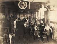
Courtesy of Samuel Yellin Metalworkers

"...the traveler finds again a past of his that he did not know he had: the foreignness of what you no longer are or no longer possess lies in wait for you in foreign, unpossessed places."

Italo Calvino

Introduction

Not until being immersed in Yale National Institute Seminar Leader Joseph Roach's stimulating two-week colloquium entitled "Invisible Cities"—coupled with mandatory readings, among them Italo Calvino's novella that possessed the same title—did I begin to actively consider what constitutes residing in an invisible city. Based on our course of study, I have drawn the conclusion that to reside connotes being a foreigner within one's surroundings: that being a foreigner in one's environment impacts countless numbers of Americans—including many students and their families who reside within or around major municipalities. This belief, in part, serves as the foundation for my curriculum unit, Whence We Stand.

I am an elementary school instructor at the Davis Street Arts & Academics Interdistrict Magnet School in New Haven, Connecticut. Since 2009, my classroom composition has been quite diverse, comprised of an average of 25 students per year with 4% interracial, 8% Asian-American, 12% Euro-American, 16% Hispanic/Latino-American, and 60% African-American students represented. The latter classification includes American-born blacks and second or third generation blacks of African and/or Caribbean ancestry. The majority hail from single-parents, low-to-moderate and middle income households. Most enter Grade 3 reading below grade level, faring proficient or below average across primary academic disciplines.

Upon canvassing my third graders, I learn that outside of occasional school excursions, the majority have never experienced key landmarks in New Haven. Parent-student-teacher discussions reveal that many who reside within the low-income pockets of New Haven proper barely travel beyond the confines of their immediate neighborhoods. Student-parent-teacher discussions additionally divulge that outside of school interaction, students bussed in from outlying communities—from as far as Guilford and East Haven to Milford —minimally set foot in the New Haven. Limited transportation, lack of time due to hectic, overlapping work schedules, limited economic resources, and/or misconceived notions about the city as a whole are oftentimes the rationale for non-visitation. The results: many of our young learners are impacted by "invisibly visible" cultural and socio-economic boundaries that impede their ability to fully appreciate and/or embrace being part of a broader, historically and culturally rich municipality. I have found that many students (and parents) too seem to adopt a narrow, "comme ci, comme ça" view of the city and its landmarks, observing them as nothing more than venues to be quickly traversed. "Foreigners in a familiar yet distant land ," they do not generally know or embrace that landmark areas right in their midst—such as the Nine Square District and its central square, the New Haven Green—and surrounding communities are landscapes layered in visible and invisible history, a history with which they may be intrinsically connected. The title of this curriculum unit—"Whence We Stand" –helps to symbolize that experiential bridge between past and present.

Based on this premise, Geography, Social Studies, Math and Language Arts could be taught so engagingly that they take on new meaning, enhanced through a new approach in exploration possibilities. Curriculum could be tweaked to help students make text-to-self-to-New Haven citizen connections. Making invisible cities visible could engage young learners who too often are disengaged because of invisible boundaries. How do we bring such a unit study to life? Could we implement visually interactive, hands-on teaching approaches to help students experience geographic transformation of their city over centuries? Could such an approach be used to help an often disenfranchised student population and their families—foreigners within familiar surroundings—see their embrace a city and proudly embrace the city and its history as their own? I contend, "Yes! Such exploration is doable"

Introducing such a pedagogic approach to young learners would spark immediate inquiry: Who were the first inhabitants of the region? Has the population changed over the ages, and if so, why and how? What was life like during the community's formative years? What were the characteristics of the region during the 17th through 20 th centuries? Are traces of those attributes visible today? These and other student-initiated questions are the focus of Whence We Stand: A Visual/Geography/History Adventure.

Targeted at students in Grade 3, but modifiable for students in Grades 2 through 5, Whence We Stand aligns with Connecticut Core Curriculum State Standards. The unit embraces a multidisciplinary approach, combining Geography, Social Studies, Language Arts (with emphasis on narrative writing), and Mathematics (with emphasis on Geometry), taking an up-close look at New Haven's geographic and historic development past and present. Through historical research, community walking tours, excursions to the New Haven Green, New Haven Historical Society, and the Center Church, and a complementary "photo-tour past and present," third graders will immerse themselves in background information regarding the transformation of the New Haven green and adjoining cross streets (to include Church, Elm, College, and Chapel) since the 18th century. Coupled with related readings, a photo expedition, memory-mapping exercise, and complementary writing activities, students will (1) come to understand the concept of time and place, and its impact on physical and human characteristics and interactions; (2) grasp the concept of regions and their impact on lifestyles; (3) immerse themselves in the shoes of individuals who resided and/or frequented the area past and present; and (4) compare and contrast photographic and historical images to get a sense of changing landscapes and their overall impact on community over time.

Students will be assessed based on the completion of project-based writing assignments used to convey their overall understanding of subject matter. As a culminating, whole-group activity, students will create an oversized poster representation of the New Haven Green and surrounding thoroughfares past and present. Literary and artistic creations will be showcased within select venues within their classroom, school, or community-based venue (e.g., the New Haven Public Library, City Hall lobby…).

Groundwork Preparation – Information Search

Before implementing the unit study, immerse yourself in aspects of New Haven's history. Contact or if possible take a preliminary excursion to the New Haven Museum. (Education and Photo Archive personnel are most helpful and can assist you in gathering invaluable visual images to support your study). Access on-line info and review copies of suggested bibliographic info contained herein with regard to the New Haven colony its formation and growth through the 21 st century. Do not, however, limit yourself to accessing textual info and historical society visits.

Take a preliminary tour of downtown New Haven, beginning with the New Haven Green. Saunter along the major thoroughfares. Take in the landscape. Make note of the masonry, ironwork designs, and pictorial images displayed in stained glass windows and surrounding architectural structures. Closely examine statues, grave sites, churches, fountains, bus kiosk and surrounding structures. Observe the diverse groups of people that populate the area; listen to the sounds… take it all in. Doing so gives you a different perspective viewing a community. Using this approach familiarizes you with the sensory experience soon to be embraced by your young learners. Tote an I-Pod or cell phone with a photographic feature to take strategic snapshots of key landmarks along Elm, College, Chapel, Church, and Temple. These pictorial images will be used at a later time for a follow-up, 3-D map-making activity.

3-D Photocards – A Mapmaking Tool

These visual resources will be used by students to create a visual map of what will be experienced during the two planned walking tours. Depending upon the number of grouped teams you have in your classroom, you will require six-to-seven 4"x 6" or 5" x 7" laminated sets these items. Photocards regarding the first excursion should be reflective of key sites or landmarks evidenced on each of the five thoroughfares surrounding the New Haven Green. Photos can be mounted on card stock, subsequently folded at their base such that each picture card stands independently when placed in an upright position. (If available, optionally use 5" x 7" wooden blocks—enough to accommodate each team—as a supportive base on which to lean select photographic images in an upright position.)

For the first excursion, I chose the following pictorial images for my students' mapping activity: College Street: the front entrance to Battell Chapel at the corner of the Elm and College, the front-gate entrance to Old Campus, and Bingham Hall at the corner of College and Chapel. Chapel Street: The Taft Apartment complex, Chipotle, New Haven Fitness, and Citibank at the corner of Chapel and Church; Church Street: Bank of America, City Hall, and the Sengbe Pieh statue; Elm Street: Calhoun College, the First Summerfield United Methodist Church, the main branch public library, and the courthouse; and Temple Street: the Trinity Episcopal Church near Chapel, the Center Church in which the underground cemetery is housed, and the United Church where most meetings regarding the abolishment of slavery were held. 1 (Note: A second series of 19 th century pictorial images to be used post the second excursion requires a lesser number of photocards. Select images can be made available through the New Haven Historical Society [see "Special Contacts"].)

Also have on hand a pair of scissors for each team, 18" x 20" construction paper, along with 20" x 1" strips of black construction paper. The latter will be placed on the larger sheets representative of walkways and thoroughfares within the depicted area.

Background History - Setting the Stage

What follows is general background info regarding New Haven history from its formative years through the 19 th century. (Note: Complement this unit with an extension study that highlights the influx of Asian, Hispanic/Latino, and others to New Haven. The supplemental unit should zero in on the 20 th through 21 st centuries because these populations began immigrating to New Haven post World War I. 2 Note that although some populations have not been mentioned with regard to the colony's formative years, the presence of these cultures is integral part of New Haven's more recent history. Visit http://www.on9newhaven.com/guide/here/path-of-stars/ to see of diverse people who worked or resided in in the Nine Square District formerly renowned for its successful factories, businesses, and theatrical venues.)

The Aboriginal Inhabitants - Pre-1638. Prior to the arrival of Europeans to New Haven, Connecticut shores, an indigenous people known as the Quinniapiack thrived in the area. The Quinnapiack dwelled in tree-bark layered wigwams adjacent to the nearby harbor and aligning rivers. In addition to the New Haven vicinity, their territory encompassed present-day West Haven, East Haven, North Haven, Hamden, Branford, and Guilford. The literal translation of the name "Quinnipiack" is "long water land" or "long water country." It is an appropriate nomenclature for a people who built their homeland near the waterways and coastline of the region. An agrarian people, the Quinnipiack were adept in planting. Among their food resources were corn, beans, and squash. They gathered and whenever required stored seasonal foods that included root vegetables, nuts, and assorted berries and grapes. Hearty stews and vitamin-rich meals were created with many of these food sources. They too were adept hunters and fishermen. Using handcrafted bows and arrows, spears, clubs, stones, traps, snares, and pits, they trapped fowl, bear, deer, and other fur animals. Their catch provided their sustenance and clothing for the people's survival. Using spears, weirs, and other hand-crafted fishing apparatus, they caught and/or harvested scale and shell fish that included clams, oysters, quahog, scallops, snails, lobster and mussels. The aboriginal inhabitants dispersed and reassembled on a seasonal basis as social and ecological needs demanded.

Unlike the viewpoints held by European settlers, the Quinnipiack did not practice the concept of private land holdings; they considered land to be a Creator-bestowed gift to be used and respected by all who dwelled therein. 3 The original inhabitants of the region had no idea that their land-ownership philosophy differed so drastically from that of the Puritans. In time, the number of Quinnipiack inhabitants dwindled because of the takeover of land by European newcomers.

image 13.04.03.02

Puritan Arrival – 1638. On April 23 of the above-noted year, a shipload of people constituting 500 religious refugees from England sailed to a new land. Lead by Reverend John Davenport and a prosperous merchant, Theophilus Eaton, they landed in Quinnipiack territory. Known as Puritans, the newcomers co-existed with the aboriginal inhabitants, establishing their settlement, and in time, overtook the territory and settled in the area, overtaking the region. By August 22, 1639, the church began to function either in an outdoor setting or in a neighboring barn. By 1640, a poorly designed clapboard meeting house was erected on the green and served as a place of worship. Within two years, the Puritans had established a form of government; during this time, they too changed the name of the settlement to Newhaven. The founding fathers hoped to transform the region into Christian utopia. Embracing old English tradition, they established a doctrine that they considered to be New England Puritanism. In time, the newcomers developed their community into a grid format constituting nine blocked regions, today referred to as the Nine Square District. The central square, today constituting the New Haven Green, served as the city's public common—a central meeting place for the city's European newcomers. The common area was used as a pasture for cattle and hogs, and initially, much of the neighboring area was used for agriculture. Crops like corn, rye, hay, and livestock were raised by families who dwelled in the area. By 1641, Newhaven settlement had grown into a community of an estimated 800 inhabitants. Homes built within the town were indicative of resident status. (In time, wealthy inhabitants dwelled in grand homes along such areas as Church, Elm, and Temple.) The colony, however, fell short of being the religious utopia its founding fathers had envisioned. 4

New Haven Slavery – Early 1600s. Although it has been recorded that slavery was not a major part of the New Haven colony, chattel slavery as it pertains to blacks existed in New Haven since the 1638 development of the settlement. People of African descent served as "black ivory" and "free labor" contributing to the wealth of the aristocrats of the colony. During colonial times, blacks often lived in the homes of their owners. They served in myriad roles laboring as craftsmen without artisan status, tillers of land, handcrafters of wood and iron, as cooks, fiddlers, washwomen, caretakers, and more. Forced to work in servitude, they were deemed the lowest economic group in the settlement. 5 Nevertheless, blacks perse-vered and dwelled within the region, making the best out of the worst of circumstance.

Special Note: During the 1600s, many blacks from such regions today known as Burkina Faso, Cote D'Ivoire, and Ghana along the western coast of Africa were captured and brought against their will to the Americas. Hailing from different ethnic groups and clans, men and women embraced different customs and mores and carried out different roles and responsibilities in their respective homelands. For example, within Ghanaian culture, select males beginning from childhood were apprenticed to in time become master weavers, ironworkers, stone crafters, or woodcarvers. From the earliest of time, these Asante craftsmen of Ghana made use of "talking symbols" known as Adinkra in handcrafted objects (see Exhibit 1).

Traditionally, the use of Adinkra symbolism was limited to use by the royal family among the Asante. These symbols—carved into wooden objects such as stools, linguist sticks, and artifacts—were used to symbolize the personality of the represented leader and his clan. Simplistic or complex designed patterns were also stenciled or woven into cotton cloth. Adinkra symbols contained thereon heralded the cloth wearer's persona and/or societal status. The symbols were also used (and today continue to be used) on cloth or clothing worn during funerary rites: the symbolism serves as a sign of remembrance and characterization of a deceased loved one. 6 Adinkra cloth was not only used to signify the spirit and personality of the dearly departed; the symbolism represented the individual's relationship with the Creator.

Many Ghanaian artisans were adept in handcrafting meaningful Adinkra symbols onto cloth, wood, and metal objects. Unjustly constrained, many of these artisans and others were forced to work as free laborers in the British-ruled colonies and newly formed American colonies.

image 13.04.03.03

This reality must be considered when examining ironworks and masonry that surrounds us in our daily lives. (The pictorial fence image embedded herein taken in downtown New Haven heralds that veracity.) Although often unheralded in the archives of history, many iron works and wood-crafted objects created during the 17 th through 20 th centuries reveal the influence of African craftsmanship: that artistry is depicted in gates, fences, awnings, and masonry.

Yale University New Haven Locale Established – 1718. Yale University was initially founded by a group of 10 clergymen lead by Reverend James Pierpont of New Haven in 1700. Each clergy minister donated a set of books for the proposed learning institution. The college was not originally based in New Haven: it was initially headquartered at the home of Reverend Pierpoint in Killingworth. By 1707, it was relocated to Saybrook, a town located at the mouth of the Connecticut River. Theopolis Eaton, one of Newhaven's two primary founding fathers, had a step grandson, Elihu Yale, a wealthy merchant from London. In 1718, Elihu is said to have donated an impressive number of books (totaling 400), a portrait of King George, and cloth items that sold for 562 pounds (equivalent to approximately $850 today). Because of his contribution, the educational facility was named Yale. 7

Special Note: Education for the working poor was inferior in the New Haven settlement. The well-to-do had better access to quality education. It fared worse for enslaved and free blacks. Despite this reality, Edward Bouchet, the son of a New Haven slave, went on to become the first African-American to earn a Ph.D. at Yale University. Referred to as a walking encyclopedia, Bouchet went on to become an empowering educator in Philadelphia and a civil rights activist on behalf of his people. 8

Industrialization & Immigration – 1800s – 1900s. Agriculture and trade were the primary industries during the New Haven colony's formative years. Farming and cattle-raising served as a way of life for many who resided therein, however, these industries proved not to be prosperous ways of building the settlement's economy. 9 By 1800, the City of New Haven contained approximately 5,000 inhabitants, of which 115 were free blacks and the remaining 85 serving as slaves. 10 A need for transportation and manufacturing expanded in the region. The need for skilled craftsmen increased. Europeans—including many newcomers from Italy—secured positions. Some blacks were employed as craftsmen, but were not granted artisan status.

Between the late eighteenth through the mid-nineteenth century, New Haven was renowned as a hardware and manufacturing center. The city's carriage industry prospered and was one of the largest companies in America. The Eli Whitney Gun Factory—sold to Winchester Arms—served as a major American weaponry manufacturer. The Sergeant Hardware Factory opened on Water Street on 1864. New Haven was booming, manufacturing everything from rubber goods to clocks. 11

During the early 1900s, Samuel Yellin, a Polish immigrant and adept metalworker, created magnificent wrought iron designs evidenced in light fixtures, enormous gates, rails, hardware, and grilles. His metalwork shop, based in Philadelphia and established in 1910, in time gained world-wide acclaim. By the 1920s, he employed as many as 250 artisans to create his commissioned masterpieces. Samuel Yellin is said to have valued not only the traditional ironworking skills of his staff, but also championed creativity of his workers, allowing his people to use their imagination when possible. 12 Yellin's ironwork designs were commissioned by wealthy clients and prestigious institutions—among them Yale University. Yale's Harkness Tower Gate is one of many Yellin's ironwork creations.

image 13.04.03.04

Amistad Rebellion – 1839. Sengbe Pieh, son of a local chief from Sierra Leone, along with 52 Mende captives from his homeland, were brought to the Americas on board the slave schooner Amistad. Shipped to Havana Cuba, they were transported by Jose Ruiz, a Spanish plantation owner, and slavetrader Don Pedro Montez to work on his plantation is Porto Principe, Cuba. Within three days at sea, post landing in Cuba, the African leader (referred to as Joseph Cinque by his captors), freed himself and his countrymen, annihilating all but the cabin boy, Ruiz, Montez, and a second mate who assisted in steering the schooner. Despite language differences, Sengbe forced the slaver-owner-turned conquered crew following a zig-zag path. In time anchored off the Long Island sound, visible from the shoreline of New Haven. Sengbe and his countrymen were charged and arrested for overtaking the Amistad and murdering its crew. In time, they were imprisoned in the New Haven jail, formerly located where the statue of Sengbe Pieh on Church Street currently stands.

Ruiz and Montez held fast to their ownership claim regarding the Sierra Leonean captives. A group of abolitionists, who referred to themselves as The Amistad Committee, convened and defended the Sengbe and his Sierra Leonean captives. Professor Josiah Gibbs of the Yale Divinity School searched for an interpreter of the Mende language. That search ended triumphantly, for he encountered a manumitted slave from Sierra Leone who could speak the language, Seaman James Covey. Euro-American abolitionists and other anti-slavery supporters stood fast their ground, raising funds to defend the captives. The handling of this case spanned three years. While imprisoned, the Amistad captives learned how to read and write. Former president John Quincy Adams was called in to defend Sengbe and his countrymen. In March 1841, the Sierra Leoneans were granted their freedom. The newly freed Africans were relocated and housed in Farmington and were, thereafter, granted permission to return to their homeland.

And So We Begin

To rouse student curiosity, share that in upcoming weeks (approximately 8 through 10) they will take an extraordinary excursion that connects the past with the present. Advise that while taking this journey, they must use all of their senses: by doing so, they will catapult themselves into time periods and places that are "invisible yet visible." The trek will incorporate making use of academic skills across disciplines in imaginative ways. We must tote sketch pads and colored pencils and technological equipment to record our findings. Emphasize that to get the most out of extraordinary journey, they must be attentive listeners, alert observers, and creative thinkers—willing to share their viewpoints, findings, and constructive arguments with one another in a mature way. They will use creative writing, drawing, and cartography skills at strategic points throughout the excursion. They too must be willing to work together as collaborative groups to make the journey most memorable and rewarding. Using such "grown up" intros establishes a tone for building vocabulary—and student buy-in. Tone set, we can forge ahead.

Weeks 1 and 2: Laying the Foundation for Collaboration

Our initial week of school will encompass establishing a classroom community where children and their viewpoints are valued. From day one, behavioral guidelines are laid. Students play an integral role in developing classroom rules, highlighting expected behaviors to be embraced by each individual therein. (The instructor serves primarily as facilitator and recorder.) Those behaviors include being respectful to one another, putting one's best foot forward even during challenging moments, following through with completing and submitting all classwork and homework assignments, and lending a helping hand to others who may need our support. Candid discussions and collaboration are encouraged.

Literary Accompaniments. Read aloud sessions will be strategically incorporated into our course of instruction to reinforce the unit course of study coupled with the social development concept of collaborative effort. Through the use of multicultural children's book resources, students will additional grasp the concepts of time and space, geographic locale, and human interaction between people across cultures in New England during the 17 th century. Collaboration and interaction between aboriginal people and colonists during the colonial period will be visualized through the use of five commendable literary works: Joseph Bruchac's "Squanto" (a tale grounded in fact told from the perspective of a Pawtucket clan member); Lynne Cherry's "A River Ran Wild," (accentuating how the Nashua people of the Massachusetts Nashua River Valley region made use of and respected the natural resources surrounding their homeland) and Kate Water's historical fiction companion book series, "Tampenum's Day" (the day in the life of a Wamponoag boy)," Sarah Morton's Day" (a day in the life a young girl during New England colonial times), and "Samuel Eaton's Day" (a day in the life of a newcomer to New England shores).

Through the use of the above-noted activities, children soon begin to internalize that community members support one another, and that we, as a classroom community, will dive into the learning experience, candidly and respectfully sharing our views, substantiating the foundation for our reasoning with finesse. Through the use of this tone-setting approach, children begin to embrace that they have a voice, that their voices and viewpoints are valued. Implementing this approach helps to set a tone for camaraderie, respect, and accountability among classroom peers. In time, the children will internalize that each student is a valued member and contributor to the community, that the way we interact and communicate with one another constitute skills that help individuals navigate effectively through life.

Classroom Set-Up. The physical classroom layout too will be established to reinforce our community philosophy. Depending on class size, tables are situated in groups of 4 or 5, labeled in accordance with the number of students per table. Students, by seating arrangement, are provided numbers. When engaged in classroom team discussions, students by seat-number designation will be provided rotating roles. (For example, during a team/group discussion, children at each table situated in Seat 1 may be called upon to serve as a recorder for the group; children in Seat 2 may serve as timekeeper, keeping peers abreast of the allotted time to complete an assignment; students in Seat 3 may serve as task master, ensuring that conversations are in accordance with the topic at hand for the group, and so on.) Ground rules established, the foundation has been made for collaborative interaction during strategic moments throughout the course of the school year.

Brainstorming Session. I make it a point to always canvass my students to determine what they already know, zeroing in on an overarching, essential question: in this instance, "What constitutes a city?" When presented with such an inquiry, my students immediately respond, "skyscrapers, office buildings, churches, museums, fire and police departments, hospitals, schools, business, people, busy streets… a basic visual sense of "city" is conveyed. Using our Eno Board (the equivalent of a Smart Board), I chart their assertions; we vow to revisit them at the close of our unit study to compare and contrast our original viewpoints and to embrace how much we have learned.

Empowering Vocabulary

image 13.04.03.05

On an ongoing basis, introduce students to basic geographic terminology upon which they will build and experientially discover as the journey progresses. The above-noted listing includes a several words with which to begin. Additionally introduce students to architectural terminology to include Baroque, Beaux Arts, and Victorian Gothic, reflective of French, English, and Italian design. Als canvass students to determine their knowledge of geometric shape terminology. Maintain a word-wall listing that includes representations with labels depicting a wide range of polygons, three-dimensional shapes, and line attribute terminology (e.g., parallel, intersecting, congruent…). Place these lists in a strategic locale in your classroom for ongoing reference purposes.

Walking Tour Preparation

To ensure that we have access to bus transportation, I plan all excursions at the start of the school year. In this regards, I schedule three 3 excursions in advance: the first to the New Haven Green and areas immediately surrounding the vicinity; the second, a trip to experience the interior of the Center Church, coupled with a walking tour to find culturally-specific images found within buildings, masonry, and ironwork structures, and last, a trip to New Haven Historical Society. For each excursion bring along paraphernalia with which students can record their findings; this is to include photographic equipment. (Note: Plan to have a picnic lunch on The Green. Have students bring bagged lunch, and tote an ample supply of garbage bags. [I too touch base with the nearby Elm Street Children's Library, notifying the managerial staff that we may drop by in the event of inclement weather and/or for lavatory usage.])

image 13.04.03.06

Before undertaking the first excursion, inform students that the initial trip will entail getting an up-close sense of the New Haven Green and surrounding areas during contemporary times. Although walking through the area during present-day times, notice that past moments in New Haven history are ever present. Traces of this reality will be evidenced as you stroll along major thoroughfares surrounding the area—along side streets, walkways, within and surrounding Yale University venues. Walking along throughout this downtown area also reveals "invisibly visible" clues reflective of diverse cultures. It takes a keen eye to identify them. Urge students to use audio-visual senses throughout the tour.

Weeks 1 – 3 : First Excursion – Walking Tour - New Haven Green & Follow-Up Lessons

Duration: Week 1 - 3-Day Session (Day 1 for the excursion; Days 2 and 3 for follow up activities)

Visited Sites: New Haven Green and Immediate Surrounding Thoroughfares

Required Supplies: An abundant supply of sharpened pencils, journals, photography equipment. (Note: Select students can be designated to serve as class photographers and have permission to bring in cameras, I-Pods, and I-Phones to make visual note of individual and group observations. Encourage them to take strategic photos throughout the walking tour.)

Convene in the center of the New Haven Green. Conduct a general talk reiterating that we will be exploring the surrounding area using a modern-day lens while looking for traces of the past seen in the present. Encourage students to use their eyes and ears to experience the surroundings. Throughout the walk, take notes and sketch pictorial images regarding their findings. Designated photographers can take snapshots of key landmarks or images.

Proceed to the Center Church. Have children zero in on the building's exterior its windows, the weather-beaten tombstones, and engravings. Ask: "What do you notice?" Many will share that the building seems as though it has been there for hundreds of years, that the inscriptions on the rear of the building and tower atop the church give it that feel. Have students discuss, record, and draw their findings.

Thereafter, head towards the corner of Elm and College Street, and proceed along College. Have students take note of architectural design and materials with which the buildings are constructed. Ask: "What do they notice about these structures?" Many children will point out the buildings' castle-like, olden-day countenance. Time and permission granted, enter through the gated entranceway of Old Campus. Have students take note of the way the interior is designed. Take in the sights and sounds within the confines of the space. Once again, take a moment to document their observations.

Continue onto Chapel. Most of the students will readily identify the many small businesses aligning the street that include new fast food eateries that span cultures (Mexican, Chinese, standard American…), vintage apartment buildings, the nearby Omni Hotel, clothing stores, and financial institutions. Some may point out that people diversity seems more prevalent on this side of the street than on those previously traversed. On the side of Chapel nearest the bus kiosk, students may notice large numbers of people of color awaiting public transportation. They too may observe people leisurely seated on benches, seemingly having nowhere to go. They may notice the sign that says "Food Pantry" on the corner church, with people seated on the front steps of that edifice? Have the children once again document their observations.

Make your way onto Church Street. As you proceed, "Ask: "Is there a different feel or energy in this locale? What conclusions might one draw from being in this area?" A few students may point out advertisements on the sides of vintage buildings announcing the availability of luxury apartments for lease or purchase. They may make note of a contemporary high-rise jutting upward from amid significantly shorter, antiquated-looking edifices. They will point out the fountain-type structure near the corner of Church and Chapel and the break in the fenced-in entranceway to the nearby flagpole housed on the Green. Students will immediately highlight financial institutions that align this thoroughfare. Some will notice designated areas for police vehicles. Again, remind students to use sight and sound to take it all in. Saunter through the area nestled between City Hall and the Federal Building. Students may notice public officials—like the mayor—darting through the vicinity. Walk further until you come upon stately bronze structure. Upon close examination, students will notice three sculpted figures therein. Ask: "Why do you think this regal structure is situated here? What is its significance?" Have students closely examine the sculpted images, carefully reading the inscription found at the base of each. The work reveals three-major historical phases of Sengbe Pieh's life and the significance of that history in New Haven. It too symbolizes the ability to overcome life circumstance despite the odds. Have students record their explanation in their journals with designated students continuing to take photos.

Evaluating the Experience

Return to the Green to have students share their interpretation of all has been experienced thus far. Encourage them to cite observed streets and landmarks, as we will be mentally revisiting these locales upon our return to the classroom.

Note: In previous years, I have taken young learners on excursions to the New Haven Green. When doing so, I have found that across abilities levels, third graders are quite intuitive. Anticipate that they will make keen (at times humorous) observations, among them:

- The New Haven Green and streets immediately surrounding the area are filled with activity.

- The Green is set up like a huge polygon divided into uneven fractional parts.

- The streets and paths along The Green look like parallel, intersecting, and perpendicular lines, and some streets and paths intersect like the coordinates in a game called "Battleship."

- All different types of geometric shapes like cylinders, cones, cubes, triangles, rectangles, rhombuses, squares, trapezoids and more can be seen in buildings.

- People from different cultures and socio-economic backgrounds seem to populate the area; you can tell because you hear different languages reflective of Asian, African and African-American, Hispanic/Latino, Middle Eastern cultures, and European cultures spoken all around you.

- Mexican, Ethiopian, Chinese, and other kinds of restaurants are downtown—they too indicate diversity.

- Mostly Whites and Asians seem to attend Yale; not many Blacks and Latinos are seen on campus, except for the workers

- A lot of people who look like they have hard times seated on benches and in front of the churches on the Green, and a lot of people of color wait at the bus stop.

- Downtown New Haven is a mix of old and new buildings.

- Some buildings look like castles built in England, Spain, France, or Ancient Greece. They were well-built because they look real old, but they are still standing.

- The buildings make me feel like rich people live in downtown New Haven.

- Images of early settlers and Native Americans are pictured in many church windows, and many of the awnings and gates contain beautiful designs.

- The courthouse and places where attorneys and criminals are closest to the corners of Elm and Church Streets.

- Sengbe Pieh's statue is situated a little between the courthouse and City Hall.

- The financial district seems to run along Church Street, while the eateries and areas for entertainment seem to be situated along Chapel

The children have gotten a sense of the ambiance of contemporary New Haven, of the city's modernity and antiquity and socio-economic and cultural diversity. They will continue to enthusiastically provide input, BUT you will have to take that welcomed break for lunch (with a few minutes set aside for clean-up, bathroom break, and at minimum two relay races). After the lunch break, discussion continues. The children's responses will reveal that they are catching on to something: the New Haven Green and surrounding areas are alive with information that transcends visual interpretation.

Follow-Up Lesson #1 – Map-making Activity.

Upon returning to class, have students continue the discussion. Have them enter into collaborative groups to discuss all they have experienced during the morning excursion. Distribute one set of photocards along with one 18" x 24" sheet of construction paper to each team, along with an ample supply of black strips to be used for thoroughfare representation. Inform students that within no more than 20 minutes, they are to place the pictured images on the provide stationery to depict a 3-D map of the New Haven Green. Using our seat-number rotational monitor selection process, designate one student at each table to serve as speaker on behalf of the group at the end of the required time. Highlight that teams will be disqualified if positive collaborative effort does not occur within the group. A special award will be given at the close of this activity. Set the timer, and have the children begin.

After the allotted time has expired, call on team representatives to share their group's map-making results. After all groups have provided their feedback, distribute a tangible or certificate for accurately completing the activity. Subsequently, have students share their views about the collaborative experience. Make note that all of the team members are winners because they put forth collaborative effort. Photograph students with map creations for future display purposes.

Follow-Up Lesson #2. Collective Writing Activity – Our Walking Tour Experience

The entire class will help to create a big book regarding the initial walking tour experience. Designate select teams to write about one of each of the five visited thoroughfares. Students should refer back to their notes and visual recollections when providing information. Have designated photographers pool together key images to be incorporated into the writing. Information and photo images will be collected and compiled by the instructor, to be subsequently presented on the Enno board for collective editing and revising purposes. Finalized work will be downloaded and posted on classroom bulletin board.

Follow-Up Lesson #3 – Shapes, Shapes, Everywhere! A Math Connection

Everywhere! Have students think one street they visited during our first excursion. Have on hand a pre-cut assortment of geometric shapes. Using pre-cut geometric shapes, glue sticks, colored pencils, crayons, and markers, have them create a front-view of the buildings that aligned their select street. Have children create a descriptive paragraph to accompany the work.

Weeks 4 – 6: Excursion: Center Church, 2 nd Expanded Walking Tour w/Follow Up Lessons

Inform students that we will be expanding our previous exploratory effort of downtown New Haven. This time, we will search for images found in architecture, awnings, fences, and more to gain deep sense of New Haven's past. The journey begins at the Center Church. A tour-guide will lead the Center Church tour. When setting up your excursion, ask that before the presentation begins, that a 10-minute window be allotted the children, during which time they will enter and quietly be seated in the pews to have an opportunity to take in the ambiance of the church. During this time, the children will have been advised to look closely at everything in the surroundings. Thereafter, the guide can begin with the in-depth presentation from the upstairs to the lower-level of the building. After the tour has ended, reconvene in the center of the Green. Ask, "What things did you find most fascinating? What did it make you feel about life during colonial times?" Call on children to respond. Expect to see excited hands waving and to have endless viewpoints shared.

Astounding Discoveries. Based on past excursions to this site, I have found that young learners are in awe of what they discover, and they too make keen observations. Upon entering the building, they immediately notice the inscriptions found on wall plaques, noting that based on some dates, it seems children died at early ages. They observe that posted names are similar to names found on some streets throughout New Haven. Upon entering the sanctuary and sitting in the pews, children state that the seats are hard, rigid, and plan. Some state that they could envision the discomfort that must have taken place after being seated for a long duration. Some students take note of the pew armrests and question, "Why are peoples' names labeled here?" A few students make personal connections: "In my church, people sit anywhere they want!—maybe they didn't do that here… maybe only rich people attended this church." The tour guide begins the presentation, and the children gain insight into their observations.

Thereafter, we quietly proceed to the lower foundation of the church. Upon exiting the narrow stairwell that leads to the underground level, the children are taken back to find a graveyard landscape. They tiptoe over cobblestone, looking closely at tombstone inscriptions. Some note that the wording engraved thereon looks like language found in the Kings James Version of the bible. Several zero in on the feel of the cobblestone, asserting that "people's feet must have hurt back then because of walking on such a bumpy surface." Many make note of the solitude surrounding the space, giving it a sacred, peaceful feel. Some children feel uncomfortable, noticing skull and crossbones on some of the grave markings. In the end, the children deduced that the Puritans were extremely religious and believed in following a strict code of conduct based on their religious beliefs.

Upon completing the tour, have students reconvene on the New Haven Green. Discuss what life must have been like for newcomers to the New Haven settlement during colonial times. At this point, provide background information regarding New Haven as noted under "Background History – "Aboriginal Inhabitants" and "Puritan Arrival." Have the children envision the surrounding area without fences and contemporary buildings as seen today; imagine rather a woodland area with a river situated nearby. Ask: "Based on what you have learned thus far, would life have been easy or difficult back then? Explain." Have students jot down their points of view.

Expanding the Tour. Proceed with the second part of the excursion—walking beyond the perimeter of the New Haven Green and surrounding cross streets. (Time permitting, include the Grove Street Cemetery.) Before proceeding, provide each student with a copy of the Adinkra symbol checklist (see Exhibit 1).

image 13.04.03.07

Instruct students to make note of intricately detailed gates, wrought iron railings, ironworks images found within doorways, awnings, gates, and intricately designed windows as they walk along Yale campus and streets beyond the New Haven Green. The symbolism found therein herald the craftsmanship of European artisans. Many Adinkra-type symbols reflective of West African culture are noticeable along High, Wall, Crown, and Church Streets and surrounding areas. Cultural clues representative of diversity are also revealed in pictorial images found in masonry, stained glass windows, and intricately carved statues. Signs and symbols all around us—some with religious or aristocratic overtones—collectively connecting us with invisible cities of the past. Students will be amazed at the number of images they find that bridge us with the city's history across centuries.

Follow-Up Lesson #1 – 2 nd Map-Making Activity

Upon returning to class, have students continue the discussion. As held true for our first map-making activity, have students enter into collaborative groups to discuss landmark images experienced during the day's excursion. Also ask that they think keep in mind landmark images that they experienced along Elm, Chapel, Church, Elm, and Temple at the beginning of the unit.

Repeat same seat-number rotational monitor selection process and set up of activity as noted in previously implemented map-making activity, except use pictorial images that reflect key 19 th century landmarks. (For this second mapping activity, my pictorial images selection included: College Street: Front view of original Yale College building with graduating class; Chapel: Trolley scene and surrounding business community; Elm: Homes that aligned the Street, then referred to as Quality Row; Temple: the three churches along and row-boating flood scene flagpole in background; Church Street: images of the original county courthouse and newly constructed City Hall.)

Once again, after the allotted time has expired, call on team representatives to share their group's map-making results. After all feedback has been provided, have students compare and contrast the images, making note of the transformation that has taken place along the New Haven Green.

Follow-Up Lesson # 2 (3 55-minute sessions, to be expanded as needed)

Required Reading: Samuel Eaton's Day. This work will be used to help students get a sense of life during Colonial Times. Sarah Morton's Day can be used as well. (Note: I have a set of these books to accommodate my entire class for whole group instruction: this work too can be downloaded for ENNO Board use and viewing during shared reading.)

This narrative writing assignment will require three to four follow-up session re: editing and finalizing the literary creation. To help students get a feel for life during colonial times, have students read Samuel Eaton's day. Upon completing the work, have students put themselves in Samuel Eaton's shoes. Ask: "Which episode in Samuel Eaton's young life did you find most fascinating? What part of his life seems the most difficult? Explain." Have students respond to these questions in the first-person voice. Encourage them to be descriptive, based on presented facts, to create an insert based on the main character's experience. Students will be required to craft and edit their writing, sharing it among classroom peers. Finished work will be placed on display on our classroom bulletin board.

Follow-Up Lesson #3 - Adinkra As Social Development Metaphor

Have students pretend to be an Asante Artisan hired to create an awning or fence design. Thinking of the persona he/she possesses, select three Adkinkra symbols to be used. Based on his/her perception of himself/herself, have students write an accompanying statement for the chosen design selection. (Visit http://www.adinkra.org to download and resize student choices.)

Weeks 7 – 10 : New Haven Museum Excursion, 2 nd Map-making Activity, Follow –Follow-Up Lessons (Day 1 for the excursion; Days 2 through 4 for follow up activities)

Reading Selections: Patricia McKissack's Amistad: A Slaveship Journey

Inform students that they are about to visit another New Haven landmark founded in 1862. Note that while visiting the museum, they will experience artifacts representative of life during the 19 th and early 20 th centuries. Look closely at the artifacts, and keep a mental note of the location of depicted landscapes. Have students take in the images— landmark locations and key images therein, the dress and style of the time. Ask, "Based on the portrayed images, how has the New Haven Green changed since colonial times? Explain. What landmark changes did you observe?" Have students record their findings. We will revisit them upon returning to our classroom.

Additionally note that during this excursion, students will observe pictorial images and view a brief documentary regarding the Amistad Rebellion. While experiencing the story, urge them to remember the image of Sengbe Pieh situated near City Hall. They will learn that in 1839, Sengbe and his countrymen were imprisoned in the New Haven jail which was originally located on the site where the statue now stands.

Follow-Up Lesson #1 - Required Reading: Amistad – A Slaveship Journey. (Note: I have a set of these books to accommodate my entire Lesson class for whole group instruction. Copy of the work can be uploaded via Amazon Kindle for shared reading purposes for ENNO Board display.)

Have students respond to key questions regarding Cinque's experience on board the Amistad vessel and during and post the trial. Have students write journal entry in the first-person voice to provide descriptive, snapshot account of Sengbe's experience. Students will be required to craft and edit their responses, sharing them aloud among classroom peers. Finished work can be placed on display on classroom or school-corridor bulletin board.

Culminating Whole Group Activity – "Downtown New Haven – A Collaborative Poster."

(For supplemental assistance, coordinate this Math/Geography/Language Arts activity can with instructors in your school's Art Department.) Have students create an oversized poster representing their view of the New Haven Green and surrounding cross streets today. Children will be required to make use of pre-cut out 5" x 7" polygons, markers, crayons, and tempura paints to design buildings and key landmarks. Photos can be incorporated into the landscapes, with images of diverse groups of people depicted in the area. Students are to create accompanying captions to describe the region, making note of important events that took place therein during New Haven's formative years. (As an extra-credit complement, have students look up street names to determine the historic or local figure for which select streets were named.) Take photos of this work in progress. Showcase final student creation, along with select snapshots for display in the classroom or select school bulletin board.

Conclusion

Via the implementation of this curriculum unit, students will be immersed in a study of their city, drawn into the multi-disciplinary learning experience through collaborative, interactive instruction. They will come to understand the concept of time and place, and its impact on physical and human characteristics and interactions. Students will experience themselves and diverse cultures as part of community. Invisible cities will be made visible, revealing realms of possibility to be embraced from within.

Bibliography

Teacher Resources

Agbo, Adolph H. Values of Adinkra Symbols. Ebony Designs and Publications, Kumasi, Ghana, 1999. The invaluable resource presents myriad Adinkra symbols and their meaning; adages are included to help one grasp the depth of Adinkra symbolism.

Brown, Elizabeth Mills. New Haven: A Guide to Architecture & Urban Design. Yale University Press, New Haven, CT (1976). Provides invaluable, architectural background info regarding New Haven history. A terrific resource to tote during a walking tour.

Calvino, Italo. Invisible Cities, English Translation, Harcourt, Inc. New York, 1974, A fascinating novella accentuating human interaction within invisible cities as conveyed in a discourse between Marco Polo and Kubla Khan; provides an nsightful view of cities using multiple lenses.

Caplin, Colin M. New Haven: Then & Now. Arcadia Publishing, Charleston, South Carolina, June 2006. Photo rich resource highlighting 19 th century architectural landmarks and points of interest in Connecticut's Elm City.

Cronon, William. Changes in the Land: Indians, Colonists, and the Ecology of New England. Farrar, Strauss, & Giroux, New York (2006). A history of the New England colonies from a cultural and ecological perspectives: a fascinating and enlightening read.

Kagan, Myrna. Vision in the Sky: New Haven's Early Years, 1638 - 1783. Linnet Books, Hamden, CT, 1989. Provides a detailed, up-close look at the New Haven colony during its formative years.

Maynard, Preston and Noyes, Marjorie (Editors). Corsets, Clocks, and Carriages. The Rise and Fall of an Industrial City. University Press of New England, December 2004. Provides historical insight and complementary photo images of industrial New Haven from the 17 to 1900s.

New Haven Colony Historical Society. New Haven: Reshaping the City: 1900-1980 - Images of America Colony. Acardia Publishing, Charleston, South Carolina, 2002. Contains fascinating B&W photos of Church, Chapel, College, and other major thoroughfares past and present. Children will marvel at the myriad edifices built between the 19 th and 20th century, some of which remain visible today.

Sobel, David. Place-Based Education. Connecting Classrooms & Communities. The Orion Society, Great Barrington, MA (2008). Emphasizes the importance of using place as a springboard to learning, deepening relationship between person, place, home, community, and interrelationships therein. An invaluable teacher resource to spark inquiry based learning across learning modalities.

___________. Mapmaking with Children: Sense of Place Education. Heinemann Press, Inc. Portsmouth, NH, 1998. A must-have pedagogic resource: emphasizes how mapping can be used as a pathway to teaching across disciplines. Stresses importance of fostering use of cartographic skills to children across grade levels, beginning with pre-school through to primary grades.

Townshend, Doris B. Whatever Happened to the Quinnipiacks? A Historical Narrative of these Native Americans Before and After the Settlement of New Haven in 1638. East Haven, CT, Minuteman Press , 2008. A handy historical resource created by this Mount Holyoke College grad and historian for the Center Church of New Haven, Connecticut.

Vlach, John Michael. By the Work of their Hands: Studies in African American Folklife. University of Virginia Press, Charlottesville, VA, 1991. This work provides background describing the evolution of Black material cultural clearly visible and often undocumented and found throughout the United States.

Children's Book Resources

Bruchac, Joseph. Squanto's Journey: The Story of the First Thanksgiving. HMH Books for Young Readers, Reprint Edition, September 1, 2007. Written by an award-winning Abenaki clansman, the work highlights lifestyles, culture, and mores embraced by Tisquantum (Squanto) and his people coupled with challenging circumstance faced by European newcomers to colonial American shores.

Caplin, Colin M . 101 Glimpses of New Haven. The History Press, Charleston, South Carolina, August 2008. Another visually informative resource created by this New Haven resident. Good compare and contrast references to reinforce reading strategies.

Cherry, Lynne. A River Ran Wild: An Environmental History. HMH Books for Young Readers, Reprint Edition, April 1, 2002. This work reenacts life along the shores of Massachusetts' Nashua River as experienced by the aboriginal peoples who dwelled within the region. Gives a sense of what life could have been like for the Quinnipiac who pre-colonial times who established communities around or near the New Haven Harbor, accentuating the need for mankind to take care of Earth's natural resources.

McKissack, Patricia. Amistad: A Slaveship Journey. Penguin Books for Young Readers, Inc., New York, December 29, 2005. An easy-to-read historical account of Sierra Leonean captive, Senge Pieh, and the Amistad Rebellion.

Rylant, Cynthia. An Angel for Solomon Singer. Scholastic, Inc., New York, September 1, 1996. A realistic fiction narrative highlighting feelings embraced by a resident who has lost his sense of community due to life circumstance, forced relocation, and environmental change.

___________. Sarah Morton's Day: A Day in the Life of a Pilgrim Girl. Scholastic Press, New York, 1989. One of three in a children's book series, serves as an engaging photo-journal account of life on Massachusetts Plimoth Plantation, as told by Sarah— nine year old girl and real-life character who resided in the New England colony in 1627.

Waters, Kate. Tampenum's Day: A Wampanoag Indian Boy in Pilgrim's Time, Scholastic Press, New York, May 1, 1996. A well-written, photo-journal, historical fiction snapshot of New England life as told by a young Wampanoag boy; last pages provide additional information regarding Wampanoag people.

___________. Samuel Eaton's Day: A Day in the Life of a Pilgrim Boy. Scholastic Paperbacks., Inc., New York, November 1, 1996. Another engaging photo-journal account of life on Massachusetts' Plimoth Plantation, as told by seven-year old Samuel, a real-life character who came to and resided in the New England colony in 1627.

On-Line References

The First Church of Christ in New Haven: A Historic Snapshot. http://www.newhavencenterchurch.org/history.html, accessed 5/13/13. Provides background information regarding this historic landmark.

http://ordinarynewhaven.com/history.php. Includes wonderful turn-of-the-20 th century photos of downtown New Haven.

New Americans in Connecticut. http://www.immigrationpolicy.org/just-facts/new-americans-connecticut, accessed 7/18.13. Provides census and background info re: the influx of Asians, Hispanics, Latinos, and other immigrant groups Connecticut townships.

The Three Churches on the New Haven Green – A Brief History http://www.u-s-history.com/pages/h2349.html History (accessed July 9, 2013)

A History of New Haven. http://www.cityofnewhaven.com/Mayor/History_New_ Haven.asp, accessed 5/13/13. Provides snapshot info on the history of New Haven during the colony's formative years.

The Society of Colonial Wars in the State of Connecticut. http://www.colonialwarsct. org/1638_quinnipiac_indians.htm, accessed 7/10/13. Provides background info regarding the colonist encounter with the original indigenous inhabitants of the region.

A Brief History of Yale. www.library.yale.edu/mssa/YHO/brief_history.html, accessed 7/10/13). Brief history regarding the initial founding of Yale College.

Fred F. Smith, M.D., Black Renaissance Man http://www.fredsmith.com/index.htm (accessed 2/12/13). Biographic sketch of influential Newhallsville resident, physician, educator, and civic activist; Dr. Smith's achievements and persona served as inspiration for establishing New Haven's annual Freddy Fixer Parade. Written by Dr. Smith's son, Adinkra symbolism is used to highlight his father and family's values.

Special Contacts

Center Church on the Green - 250 Temple Street, New Haven, CT 06511

Telephone: (203) 787-0121

New Haven Colony Historical Society - 114 Whitney Ave New Haven, CT 06510

Director of Photographic Archives Contact Jason Bischoff-Wurstle - (203) 562-4183, EXT 18 and Director of Education Contact: Michelle Cheng - (203) 562-4183, EXT 11

Appendix – Implementing District Standards

The following Common Core Standards are addressed in this curriculum unit:

SOCIAL STUDIES – SS1.3,SS1.4, SS1.5, SS1.6, SS2.2, SS2.3, SS2.4 - Geographical Space & Place, Information Literacy and Communication, and Global Awareness, Critical Thinking & Problem Solving: Students will investigate the origins of prominent and less prominent individuals past and present, examining their heritage and influence on the community; identify geographic features and create geographic representations of those features via the use of maps and models; analyze how and why people settled in specific communities and how people and communities have an impact on their environment; participate in collaborative conversations with diverse partners; respond to questions based on discovered and provided info; interpret information from various primary and secondary sources (e.g., walking tours, photographs, and other pictorial images); create various forms of written work across genre based on gathered information; and will present info gathered on a collaborative group or independent basis using clarity, voice, and fluency.

MATHEMATICS (Geometry & Measurement) – M3.1, M3.2 - Students will recognize that shapes and structures can be analyzed, visualized, measured, and transformed using a variety of strategies, tools, and technologies; identify, draw, and construct two-and-three dimensional shapes; compare, contrast, and identify polygons and solids; draw and interpret simple maps and/or pictures using coordinate grids, investigate ways to tessellate a shape or regions using a variety of polygons and other geometric shapes, use spatial reasoning, location, and geometric relationships to problem solve.

LITERACY - RR1.4, ERL2.1, ERL2.4, CWO 3.1, CWO 3.2, CWO 3.3 - Reading and Responding, Exploring and Responding to Literature, Communicating with Others: Students will communicate with others to create interpretations of written, oral, and visual texts, explore and respond to literature; recognize that readers and authors are influenced by individual, social, cultural, and scientific context; use oral language with clarity, voice and fluency to communicate a message, will use the appropriate features of narrative, expository or poetic writing, use strategies to generate and develop ideas for speaking, writing, and visual activities, and publish and present final products in myriad ways, including the use of the arts and technology.

image 13.04.03.08

Photo & Pictorial Credits

Yellin Metal workers photo featured on curriculum unit cover page, permission for use granted by Samuel Yellin Metalworkers.

Pastoral image on the New Haven Green thumbnail image, permission for use granted by Jason Bischoff-Wurstle, Director of Photographic Archives, and the New Haven Historical Society.

Photos of the Sengbe Pieh (Joseph Cinque) statue in front of New Haven's City Hall, the shadowed fence Adinkra symbolism, and Old Campus ground image, permission for use granted by Yale National Initiative Fellow Jeffry Weathers.

Featured Adinkra symbols on Exhibit 1 made available via downloadable for educational use Adinkra website @ http://www.adinkra.org.

Notes

1. http://www.u-s-history.com/pages/h2349.html (accessed July 9, 2013) The Three Churches on the New Haven Green – A Brief History

2. http://www.immigrationpolicy.org/just-facts/new-americans-connecticut (accessed June 18, 2013). New Americans in Connecticut.

3. William Cronon. "Seasons of Want and Plenty" in Changes In The Land, 34-38

4. Shumway, Floyd and Hegel, Richard, Edtrs. "New Haven: An Illustrated History,"

7 - 24

5. Ibid., 41

6. Adolph H. Agbo. "Values of Adinkra Symbols", 12 -15.

7. http://www.library.yale.edu/mssa/YHO/brief_history.html (accessed July 10, 2013)

8. Floyd Shumway and Richard Hegel, Editors, "New Haven: An Illustrated History"

9. Ibid., 18-28

10. Ibid., 40

11. Ibid. 66-68

12. http://www.brownstoner.com/ blog/2013/01/ walkabout- samuel-yellin-master-of-iron

(accessed July 13, 2013) "Walkabout: Samuel Yellin-Master of Iron.


Comments (0)

Be the first person to comment

When you are finished viewing curriculum units on this Web site, please take a few minutes to provide feedback and help us understand how these units, which were created by public school teachers, are useful to others.
THANK YOU — your feedback is very important to us! Give Feedback